
Overview
Goal
Expand and improve a ground-based Allsky camera network to aid in the research of atmospheric phenomena, centered around the detection and tracking of the atmospheric impacts of large Bolides in support of U.S. Near Earth Object (NEO) Impact and Hazard Mitigation Programs.
Objectives
- Deploy a network of Allsky cameras around the Globe
- Develop a network to access data, archive data, and make the data available for processing and analysis by interested parties
- Develop software tools for calibration, removal of detector effects and anomalies, automatic correlation among stations, and automatic trajectory computation
- Develop a companion multi-band radiometer to improve the diagnostic capability of the camera network
- Develop a next-generation, High-Definition (HD) Allsky camera with autonomous, remote operations capabilities for deployment anywhere
What are we building?
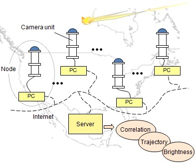
- Cameras: Uplooking wide-field, HD video
- Network: Volunteer and autonomous nodes around the Globe
- Server: Central server to correlate and catalog events and provide a forum for collaboration
Past and Current Camera Locations
node is online (circle: approximate coverage area)
deployed, not online
Every node on record is shown: 47 online now, 75 in all. Click a marker to open that node.